Vision of the future
SARsatX
SARsatX is a space startup in the GCC and Arabia that designs and develops small satellites to do Earth Observation (EO) using Synthetic Aperture Radar and provide data for many sectors to support decision makers.
SARsatX is a spin-off of TAQADAM Startup Accelerator, incubated and funded by King Abdullah University of Science and Technology (KAUST), and supported by Saudi Space Commission, UAE Space Agency and MiSk

Mission
The leading and most innovative Arab company in space industries, and services.
Vision
Provide data from space to help make better decisions on earth.
Technology
At SARsatX, we utilize the most innovative and precision technologies.
What do we offer?
Earth Observation from Space to Arabia

Precision
Radar measurement are naturally precise. When radar data are combined with commodity GPS orbit-determination processes, they are used to form images that are in line with the geolocation revolution. SARsarX data has state-of-the-art geolocational accuracy matching the scale of the pixel.

Coverage
SARsatX has quad-polarization with a wide range of collection modes ranging from small-area spotlights with sub-meter resolution to large-area StripMaps with resolutions from 1-to-3 meters.

Quality
SARsatX uses the most advanced commercial radar imaging technology available and is based on space proven TRL9 radar technology used on satellites that have been taking high-quality, excellent signal-to-noise radar images for several years
Advantages of SARsatX
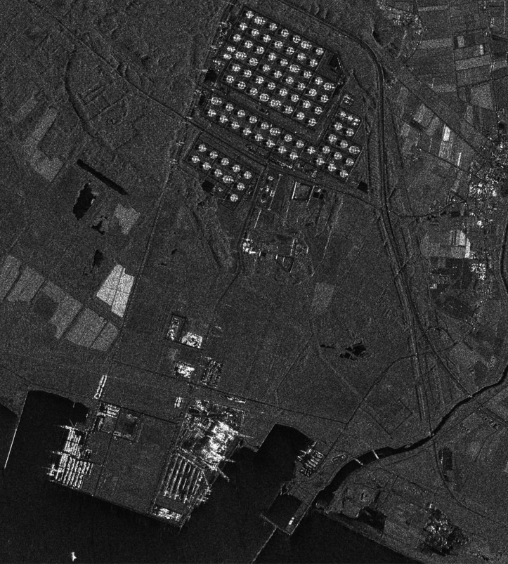
Radar Imaging
SAR imaging is characterized by its ability to monitor the Earth over a 24-hour period, day or night, regardless of weather conditions and obstacles due to its ability to bypass clouds and smoke, enabling you to obtain recent data on the Earth’s surface. Thus, SAR technology is able to offer many advantages that traditional Earth observation methods – such as optical imaging – cannot provide.
Our Solution
State-of-art technologies and capabilities
- SAR Imaging.
- Constellation.
- Super Resolution Signal Processing Patent.
- Machine Learning.
- Space Mission Design.
Innovative people
who challenge each other for greater good.
Bold spirit
that pushes us for more achievements.
Honesty
that raises the bar for collective moral standards.
Cooperation
that embraces differences, inspires and unlocks potential.
Simplicity
that kindles innovation, agility and impact
Technologies
Constellation
SARsatX works on a constellation of 18 satellites that are specially designed to ensure the best level of service for our customers at GCC as it is able to provide them with the required data of various types and patterns within four hours only, which we aim to operate at full capacity by 2027.
Satellite Constellation delivers reliable and timely SAR imagery. A large constellation distributed uniformly enables us simultaneously to reach a high speed of response and to frequently scan large areas at the same time. A large SAR constellation offers an enormous amount of acquisition possibilities to capture the territory of entire nations at high resolution, and more, in a single day. The imagery of SAR satellite constellation is not constrained by weather conditions or the need for sunlight.
Join the innovation
Data from Space
for Better Decisions on Earth
Explore the World of Satellite Imagery with SARsatX
Satellites are not just space tools; they are vital elements that significantly impact our daily lives. From weather forecasting to communications and military surveillance, satellite imagery enhances our quality of life in unexpected ways. At SARsatX, we offer a unique experience in the realm of satellite image capture and analysis, thanks to the latest technologies we provide.
With our advanced technologies, we empower you to gain accurate and comprehensive insights into the environment, weather, and various geographical areas through satellite images. Our services utilize cutting-edge space imaging methods, such as hyperspectral imaging and big data analysis, to deliver high-quality information that helps you make fact-based decisions. We believe that technology can revolutionize your understanding of the world around you, which is why we offer sophisticated tools and techniques to help you achieve your goals and analyze environmental challenges through satellite imagery.
By utilizing satellite images, you can monitor environmental changes, such as shifts in vegetation and water bodies, and address natural disasters more effectively. We provide you with precise data that aids in in-depth analysis, enhancing your ability to make timely, informed decisions using satellite imagery.
Embark on a unique exploration journey with SARsatX and discover the limitless possibilities that satellite imaging technologies offer. We are here to support you with advanced analytical tools and customized services that meet your needs, turning every exploration experience into an opportunity for excellence and innovation. Invest in the future today and be part of the technological revolution driven by satellite imagery with SARsatX.
